A snug, well-protected anchorage tucked into a narrow inlet at the mouth of Barkley Sound, fronting the famous Bamfield boardwalk village and its public docks on Vancouver Island's wild west coast.
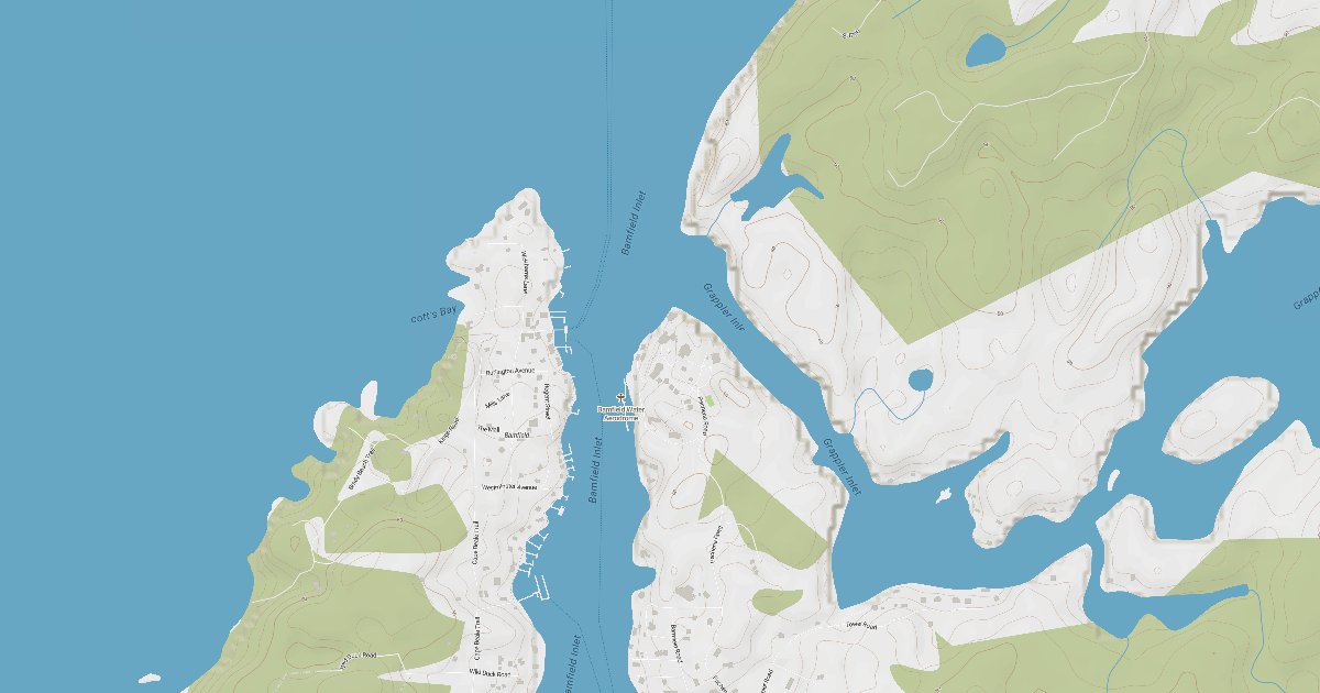
Bamfield Inlet cuts a slender, sheltered notch into the southeast corner of Barkley Sound, splitting the boardwalk community of Bamfield into two halves. The west side is car-free, linked only by a wooden boardwalk that threads past homes, the general store, lodges, and the Bamfield Marine Sciences Centre; the east side holds the road, the main grocery, and the bulk of the village services.
Most cruisers anchor in the obvious basin in the inner inlet, behind and just north of Rance Island, where the water is calm and the holding is reported as very good. The setting is peaceful and picturesque, broken only by the occasional passing sport-fishing boat or floatplane, with public and guest docks giving easy shore access to one of the most charming, boater-friendly stops on the outer coast.
Approach notes, hazards to watch for, and what's available once you're tied up.
Bamfield is approached from Barkley Sound via Trevor Channel, the broad eastern channel that leads to the inlet mouth. Despite a busy appearance on the chart, the entrance to the short inlet is fairly easy to run if you follow the piloting advice in the cruising guides; the channel is narrow but well charted, with controlling depths adequate for cruising boats.
The key hazard is the overhead power line crossing the inlet at the entrance, with a published clearance of about 56 feet, which restricts taller sailboats. Watch for rocks and shoaling along the inlet edges, give Rance Island and unmarked reefs adequate berth, and stay alert for floatplane traffic and small craft in the confined fairway. Consult CHS Chart 3671/3646 and a current cruising guide for exact soundings.
Wind protection summary and tide planning at a glance. Full per-direction and 7-day detail with Plus.
Live readings from the nearest OpenWeather station and WorldTides; refreshed every few minutes.
Source: OpenWeather One Call API + WorldTides.
A curated photo + map walkthrough showing approach, mooring options, and points of interest.
A guided walkthrough of Bamfield with approach photos, depth notes, and points of interest — written by members who have been here recently.
Real first-hand reports and questions answered by members who have actually been here.
No reviews yet. Be the first.
Cruising info goes stale fast — fees change, fuel docks close, hours shift. WalkTheDock stays accurate because boaters who’ve actually been here keep it current. Spot something out of date? Suggest a correction; once a moderator approves it the change goes live and you’re credited below.
No community updates yet — spotted something out of date? Use “Suggest an edit” below.
Please log in to suggest edits.
Log inCruising-distance picks near this anchorage.
Barkley Sound · 7.9 nm away
West Coast Vancouver Island · 10.1 nm away
West Coast Vancouver Island · 36 nm away
West Coast Vancouver Island · 51.9 nm away